 |
 |
Contents
Click on the item to go to the article. |
Editorial CommentIn this issue, continuing the First world
War theme, we have two very different stories provided by two of our members. |
Forthcoming Events
| 2013 | ||
| Date and Time | Event | Venue or Meeting Point |
| Tuesday 21st October 19.30 |
“Comtemporary Heritage Protection in Bath” - Talk by Ian Lund | Haden Room, United Church, Church Street, Trowbridge. |
| Tuesday 25th November 19.30 |
PUBLIC LECTURE - “Trowbridge Barracks Project” by Neil Ashley |
Haden Room, United Church, Church Street, Trowbridge. |
| 2015 | ||
| Date and Time | Event | Venue or Meeting Point |
| Tuesday 13th January 19.30 |
New Year Social with Quiz. Please bring a plate of food (if you can) – Drink provided. Subs for 2015 may be paid this evening. |
Assembly Room, United Church, Church Street, Trowbridge. |
| Tuesday 17th March 19.15 |
Annual General Meeting and Talk (speaker to be announced) | Haden Room, United Church, Church Street, Trowbridge. |
FROM THE CHAIRMAN |
In September last year the Town Council asked County Highways not to remove a Trowbridge Roads gulley next to the new development in York Buildings. The request was made because the new development would require some work to be done to the highway. All gullies marked Trowbridge Roads are certainly the oldest in the town and among some of the oldest in the country. They are part of our town's heritage. There were at that time only ten still left. (See picture page 2).
Early in the New Year it was discovered that the gully had been replaced with a new one. The developers, Persimmon, were not interested in finding out where it had gone and County Highways department was less than helpful. Councillor Blakemore was actually sent a picture of a Dudley & Dowell gully purportedly taken from York Buildings to their depot and it was still fixed in concrete! There were no Dudley & Dowell gulleys in York Buildings. Earlier in the summer Ken Rogers took a group to see the gully in Castle Street only to discover that it too had been removed which now leaves only eight still in situ.
We are grateful that Roger Newman has recorded them in his book ‘Cast Iron Street Furniture & Business Names’. Roger has been writing to County officers to try to get the truth about this second gully but so far has drawn a blank largely because Council members are being fed ‘misinformation’ by the officers. I will let you know the result of Roger's efforts at our next meeting.
Planning Matters |
When looking for items to include in the newsletter, I tend to look for listed building applications and planning decisions that will be seen by or affect a large number of Trowbridge residents. In the centre of town, vehicle sales premises in Union Street are to be redeveloped for 6 houses with the removal of some unlisted buildings and conifer trees. The railway station approach is to be enhanced by the addition of a kiosk selling coffee, confectionery and newspapers and, out of the centre but much frequented, Mcdonalds restaurant has been given permission for a new island for signage and the reconfiguration of existing signage with additional signs.(You can obviously never have enough signs!) Land to the rear of G M Stevens and Co. on Canal Road is to change use from an engineering workshop to a hand car wash and motor vehicle workshop.
Permission has been granted for the construction of a community garden on land between Kingswood Chase and Sheridan Gardens, Studley Green. This seems a very positive development and the planning officer's report states that “The proposal would provide a community facility that would enhance the ordinary grassed appearance of the site as it currently stands and bring it into a more functional use. It should be anticipated that increased use will be made by the community of the site for gardening and relaxation”.
Brook Cottage, a listed building in High Street, Semington, has permission with conditions for a two storey rear extension and the restoration of the existing stable and coach house with a proposed new double carport.
Reasons for the few applications that are refused are also of interest. Permission was not granted for the erection of two dwellings on the site of a former tennis court in Clarendon Road because “The proposal would result in the loss of an area of land that currently fulfils an important amenity and recreation function.” Also in Clarendon Avenue, permission was refused for a two bedroom starter home on the site of an existing double garage. The reasons being that, “The proposal by reason of its design, layout, scale, bulk and mass would constitute an overdevelopment of the site that would be incongruous in appearance and fail to respect the character and rhythm of the street scene; and would therefore be significantly harmful to the character of the area and the quality of the surrounding architecture” and that “The proposal by reason of the first floor south elevation bedroom window being in close proximity to the boundary with No 42 Clarendon Avenue would cause a detrimental level of overlooking leading to an adverse loss of privacy of their rear garden.” A third application was also refused. This was for the construction of a new four bedroom dwelling with integral parking on land west of Jasmine House, Hilperton Road, opposite Fieldways Hotel. The grounds for refusal were that “The proposal would, because of the location, massing and incongruous design of the dwelling on this paddock, result in a visual intrusion into this corridor of open space at the entrance to Trowbridge that would be harmful to the setting of the conservation area and street scene.”
It is reassuring that planning officers are giving careful, critical consideration to applications and not just nodding them through.
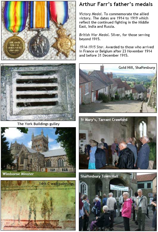
Arthur Stanley Farr |
Arthur Farr was the uncle of our secretary, Celia Russell. 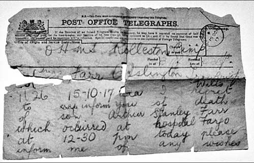 OHMS Rollestone Camp 15th October 1917. 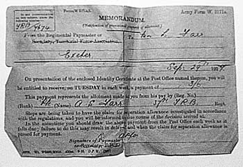 | 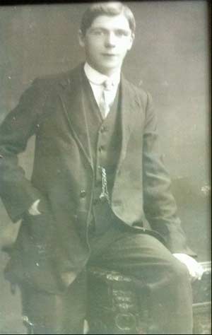 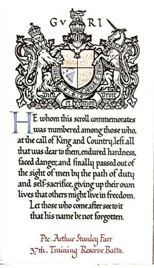 Army Form W 3171A
Memorandum - Notification of This form says that Mrs L Farr “will be entitled to receive on TUESDAY in each week, a payment of 3/6. This represents the allotment made to you from his pay.’ |
The Soldier's Penny |
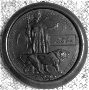 Bronze death plaques like this one were sent to the next of kin of every commonwealth man or woman who lost their lives as a result of Great War service. The
plaques were also sometimes known as the ‘Soldiers Penny’, or the ‘Dead Man's Penny’. For Home Establishments, Western Europe and the dominions the qualifying dates were from the 4th August 1914 until the 10th January 1920. The plaques measure approximately 4¾ inches (121mm) and weigh approximately 11¾ ounces (333gms). They were posted to the next of kin protected by a stout brown cardboard, purpose made folder, which was then put into a white HMSO envelope.
Bronze death plaques like this one were sent to the next of kin of every commonwealth man or woman who lost their lives as a result of Great War service. The
plaques were also sometimes known as the ‘Soldiers Penny’, or the ‘Dead Man's Penny’. For Home Establishments, Western Europe and the dominions the qualifying dates were from the 4th August 1914 until the 10th January 1920. The plaques measure approximately 4¾ inches (121mm) and weigh approximately 11¾ ounces (333gms). They were posted to the next of kin protected by a stout brown cardboard, purpose made folder, which was then put into a white HMSO envelope.
As early as October 1916 the Secretary of State for War, David Lloyd George set up a committee ‘to consider the question of a memorial to be distributed to the relatives of soldiers and sailors who fall in the war ...’. In August 1917 the Government announced a competition to design a small memorial plaque for the next of kin of the fallen. ‘The Government are offering prizes amounting in all, to not less than £500’. There were 800 entries. The first prize of £250 went to Mr Edward Carter Preston of the Sandon Studios Society, Liverpool. Edward Carter Preston's initials are embossed just above the lion's right forepaw. The original estimate had been for 800,000 plaques, but it has been estimated that some 1,150,000 were eventually produced. Of those about 600 were to women.
It was quite common for bereaved households to prominently display the plaque of their deceased loved one, often with their medals, as a small domestic shrine. A variety of commercially made holders or frames were offered for sale, which were frowned on by many. But often a home made, lovingly prepared frame would be produced to house the plaque.
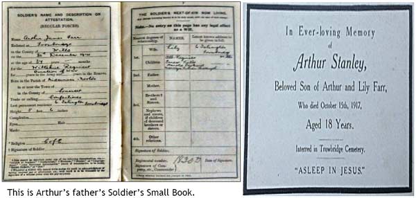
The Soldier's Small Book allowed him to carry a concise record of his Army service, and assorted information that would prove of use during service, from details of his attestation, next-of-kin, fines, saluting, badges of rank, rifles and kit cleaning instructions, to assorted recipes suitable for field cooking, notes on marriage, civil employment after service, wills, how to prevent sore feet and much more!
| Corporate Member: | The Trowbridge Museum |
Trowbridge Connections Part 2 |
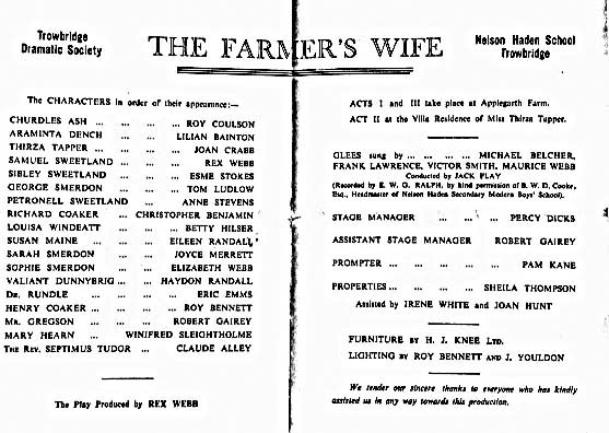
Lilian Bainton has contacted us with a little more information about Christopher Benjamin whom we wrote about in the last issue. She has an old theatre programme and has this to say.
&ldquoThe original Trowbridge Dramatic Society performed The Farmer's Wife, a comedy by Eden Philpotts, at the Nelson Haden Girls' School in December 1954. On the opening night two members definitely had ‘first night nerves’. Myself, cast in my first major role and Chris. We all knew that his father would be in the audience and afterwards he had arranged to consult the producer. On the strength of his opinion Mr Benjamin would decide whether or not to allow Chris to take up his scholarship at RADA.” The producer obviously gave a good opinion.
Many of the names in the programme will probably bring back memories for some of our members.
RECENT MEETINGS: |
Outing 14th August |
On 14th August members of the Civic Society enjoyed a visit to Shaftesbury. In the Town Hall we were given a great welcome by the Mayor and by the Shaftesbury Civic Society, followed by a tour of the town and museum and the famous Gold Hill. Then on to Wimborne for a lunch break and a tour of the beautiful Wimborne Minster, the highlight being the chained library. On our return journey some of us took the opportunity to visit St Mary's Church, Tarrant Crawford to see the 14th century paintings on the walls of the nave.
Thanks must go to Celia for organising a lovely day.
Photographs are on page 2 taken by Sally, Donald and Barbara King.
Samuel Henry Pulford (1895-1974) |
The first child of Samuel Keeling and Mary Jane Pulford was born on 8th November 1895 at 11 Hatchard Road, Islington, London. His father was a Londoner, but his mother, formerly Mary Jane Sims, came from Trowbridge. His father died on 3rd March 1909 of T.B. at 124 High Street, North Finchley and his mother died on 15th September 1910 of heart failure at Finchley Cottage Hospital.
Samuel Henry Pulford, now an orphan, aged 14¾, joined T.S. Arethusa, at Dartford, Kent, on 14th October 1910. The 2,216 ton Arethusa was the last British warship to see action under sail alone during the Crimean War. After repairs to her extensive damage during the battles of Sebastopol and Odessa, she was moored on the Thames, to be used as a training ship by the charity known as the National Refuge for Homeless and Destitute Children, which later became the Shaftesbury Society under its president Lord Shaftesbury. After living on the ship for a year and being trained in seamanship, Sam's service with the Royal Navy began.
Over the next three years, while ranked as a Boy, he trained as a gunner at shore stations in Suffolk and 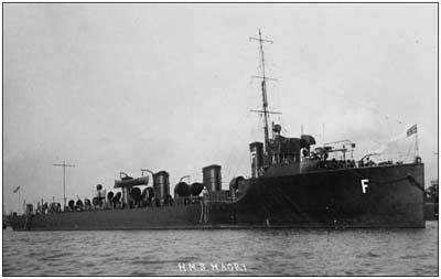 Portsmouth, alternating with periods at sea. On his 18th birthday, he signed up to the Royal Navy for 12 years as an ordinary seaman. He was described as: height 5’ 4¾”; chest 30¾”; hair
brown, eyes brown, complexion fresh with a tattoo of a dragon on his left arm and a snake on his right.
Portsmouth, alternating with periods at sea. On his 18th birthday, he signed up to the Royal Navy for 12 years as an ordinary seaman. He was described as: height 5’ 4¾”; chest 30¾”; hair
brown, eyes brown, complexion fresh with a tattoo of a dragon on his left arm and a snake on his right.
He was on HMS Crusader when WW1 broke out. He was re-graded to Able Seaman on 1 Nov 1914. HMS Crusader and HMS Maori were both Tribal Class Torpedo Boat Destroyers, built in May 1909 by William Denny & Brothers of Dumbarton (on the Clyde).
On 7 May 1915 HMS Crusader and HMS Maori were spotting for German batteries near Dunkirk, when HMS Maori was mined and started sinking. Her crew abandoned ship
and HMS Crusader lowered her boats to go to the rescue. The German shore battery fire was so fierce that 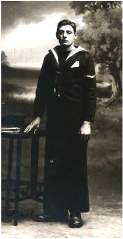 HMS Crusader was forced to leave the scene, leaving
some boats behind. HMS Maori's 95 officers and crew and some of HMS Crusader's boat crew, including Sam, were captured by the Germans and taken to Zeebrugge as prisoners of war. The actual location of HMS Maori was 2 miles NW of Weilingen Lightship, near Zeebrugge. HMS Crusader continued in service throughout the war and was sold for breaking in 1920.
HMS Crusader was forced to leave the scene, leaving
some boats behind. HMS Maori's 95 officers and crew and some of HMS Crusader's boat crew, including Sam, were captured by the Germans and taken to Zeebrugge as prisoners of war. The actual location of HMS Maori was 2 miles NW of Weilingen Lightship, near Zeebrugge. HMS Crusader continued in service throughout the war and was sold for breaking in 1920.
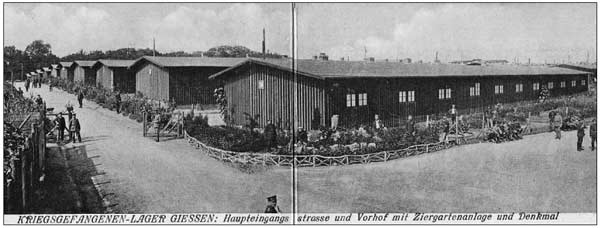
Sam spent the rest of the war as a prisoner at Giessen from 1 Jul 1915 to 13 Nov 1918. The POW camp of Giessen was in the province of Hesse in Bavaria. I don&39;t know what it was like when Sam went there, but by 1918 it was a well ordered camp with a church hut. Prisoners were allowed to write (censored) letters home and receive food parcels. The men were sent out to work, to cover the cost of their food and ‘lodging’. The fortunate ones were farm labourers, who were at least sure of some fresh food. Some others worked in a local ironstone mine, loading the ironstone into trucks. Another job was in a smelting factory, but the worst was in the tannery. Here cow hide was soaked in lime to be used for leather. The hair was scraped off and used to stuff horse collars and mattresses. Soon after 11th November 1918, the prisoners were deloused, shaved and scrubbed clean. Their disinfected uniforms were returned to them and they left to return home.
 The above account is taken from a survivor's memoirs, so I do not know how accurately it describes Sams experiences, as he never talked about it.
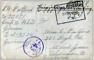
This postcard with Sam's photograph on one side was sent from the camp in Giessen in Germany to his sister, Mary, whom the family called Cissie. It typically only shows his name and number as no message was allowed.
Sam was released on 14th November 1918 and returned to England. He continued his career in
the Royal Navy continued until 1934, but the years from 1919 onwards are not reproduced here. He was a Petty Officer from 1928. A picture of Samuel in Navy uniform with his brother and sister, Percy and Mary was taken around 1920. His marriage to Olive Hunt was during the last three months of 1928, in Trowbridge, although it is known they lived in Portsmouth at the start of their marriage, before settling at 12 British Row for the rest of their lives. They had one son, Keeling. Throughout his service as an adult, an annual assessment of his character and ability is recorded (1913-1928). Every year his character was ‘V.G.’ and his ability was always ‘satisfactory’ and quite often ‘superior’. He received three WW1 medals inscribed ‘J14250 S.H. Pulford A.B. R.N.» A fourth medal, for ‘Long service and good conduct’ is inscribed HMS Excellent and his rank is L.S. Sam suffered from deafness late in life, almost certainly caused by all the guns he worked with. He died in Trowbridge in 1974. Samuel Henry Pulford was my uncle | 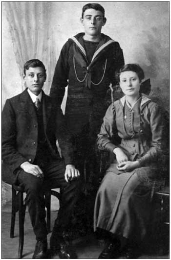 |
| |
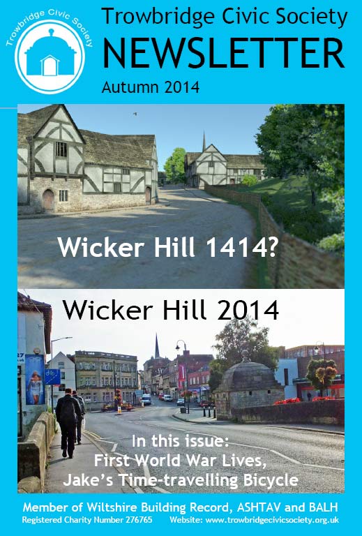
Jake's time-travelling Bicycle |
Jake Dowell has produced a fascinating website about medieval Trowbridge. He has used computer modelling to produce pictures of what Trowbridge might have looked at in 1400. His website is at http://jakestimetravelingbicycle.weebly.com/
I asked James about his project. Images from the site are on the next page.
I was looking for an old map of Trowbridge and Google pics took me to one that looked rather odd on the Wiltshire Community History website. Looking at it closely revealed a very different town layout than I would have expected even for 1773 when it was published.
It is from the Andrews' and Dury's Map of Wiltshire, of 1773. Andrews' and Dury made their county maps when there were no railways or even canals. The only way you could travel was by horse drawn carriage or on horseback. With getting around to survey impossible, I think they resorted to collecting maps. And the one they acquired of Trowbridge was medieval. They copied it as a tiny street plan drawn to a larger scale than the surrounding countryside, so elements of it are distorted as if looking through a large magnifying glass or seeing it reflected in a spoon. One of the oldest houses in town, 9 Church street (built in 1439), or even the street it sits on isn't on the map. Which intrigued me. I didn't think a map of the town that old existed. And I find it fascinating that although they've added a few bits of information contemporary for them, like the turnpikes and locations of nobles houses. Essentially the road map of 14th century medieval Trowbridge is all there.
So anyway I took a Google satellite view of Trowbridge and started to draw where I thought the old extinct roads went and it grew from there.
How long did it take?
I found the map in Feb 2014 and doodled around now and then finding where everything went,
but when I decided to do the model it took 10 weeks pretty solid modelling.
What software did you use?
I used Sketchup 8 and Thea render. Thea render is fabulous; it really brings a Sketchup model to life. Though it's slow, and to render all the frames of a walk through movie animation would probably take from now until Christmas :)
How much research was involved?
It started quite casually with the thumbnail history at the bottom of the same page that contained the map, and got more and more involved as I got more and more interested. I also saw a documentary on BBC about a Shipham butchers business that is 500 years old. There was lots of info in there about the workings of a typical Shambles. And I viewed 2 videos of bulls being killed. In the videos there's lots of blood, but it congeals rather than running away. So without drainage could be scraped up and composted.
I also found some good books in the library with lots of pictorial evidence, and The Trowbridge castle DVD from Artifact IT was very good too. In there is the survey of 9 Church Street by Richard Haddlesey. The map the model is illustrating only has squarey blobs to indicate most buildings, so they needed to be credible for the time, their function and location. Anyway, as the map shows the castle so comprehensively obsolete, yet 9 Church Street (that was built in 1439) isn't on the map, I think 1400 is the latest era it could portray, and likely to be able to include the lovely Merchant house in Fore Street where Bowyers first started trading.
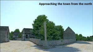
Someone said about England that “All the roads go around something that used to be there”. So a lot of what I did involved pattern recognition. I superimposed the 1899 map onto of the Google satellite pic to see features lost during the 20th century, especially around the castle. I checked out building lines and features, both on the maps and on the ground and asked why are they like that. When I drew the lost roads they had to work, they had to be going somewhere and follow a working trajectory. The simple approach from the north that forked to either the castle or the town is now gone completely. I suppose someone thought it was a good idea to block off the 2 main arterial roads leaving their descendants for the next 500 years to rat run all over town to get anywhere.
 What is your next project?
I don't know. If there is some good evidence and records I quite like the idea of doing the centre of Bradford on Avon when it was a ford, before the north of the town was quarried and the biggest show in town was a monastery.
Has the project changed your view of Trowbridge?
Yes! Before I did this project I didn't like Trowbridge that much, but now I love it. The 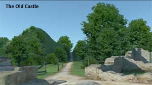 Transforming Trowbridge project concluded that it lacks a well defined centre and so sense if place. I think this is because as the town developed the centre moved. When the castle was alive, St James market was the centre. When the castle closed, the centre shifted to the manor, shambles and market in Fore Street. When the St James market was developed it shifted back there again, and when the Town Hall and covered market was built it
 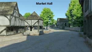 shifted there. If a spider shifts the centre of its web while it's spinning it, it'll look a mess and so Trowbridge is a angle of roads, and it used to be a tangle of roads to me too, but now I can see why. I read that tangle can see the whole historic town centre, and to me now it has a coherent sense of place.
Every time I walk up Wicker Hill on my way to Sainsbury's I see the 1400 Trowbridge. The centre of Trowbridge stretches from Wicker Hill, 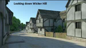 along Fore Street to the front doors of the Town Hall. The pedestrianisation of Wicker Hill can't come soon enough. It would fully return Trowbridge's sense of place, it's historic core. When I look up Wicker Hill at 6 in the morning, and
see no traffic, it looks fabulous. It's a winding street of ornate Bath stone buildings. Show pics of Trowbridge to people all over the world especially in the US and they tell you it's a lovely town, and I'm glad we're all now waking up to that ourselves.
along Fore Street to the front doors of the Town Hall. The pedestrianisation of Wicker Hill can't come soon enough. It would fully return Trowbridge's sense of place, it's historic core. When I look up Wicker Hill at 6 in the morning, and
see no traffic, it looks fabulous. It's a winding street of ornate Bath stone buildings. Show pics of Trowbridge to people all over the world especially in the US and they tell you it's a lovely town, and I'm glad we're all now waking up to that ourselves.
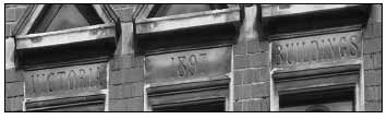
Terraces in Trowbridge. |
Walking around Bath it is easy to read the street or terrace names because, as well as white on black name plates, names are often carved in capitals on the string courses of the elegant terraces. In Trowbridge this is rare and I have only spotted five names carved in stone. The others are metal. Answers on page 2. Please let us know of any others that we have missed.
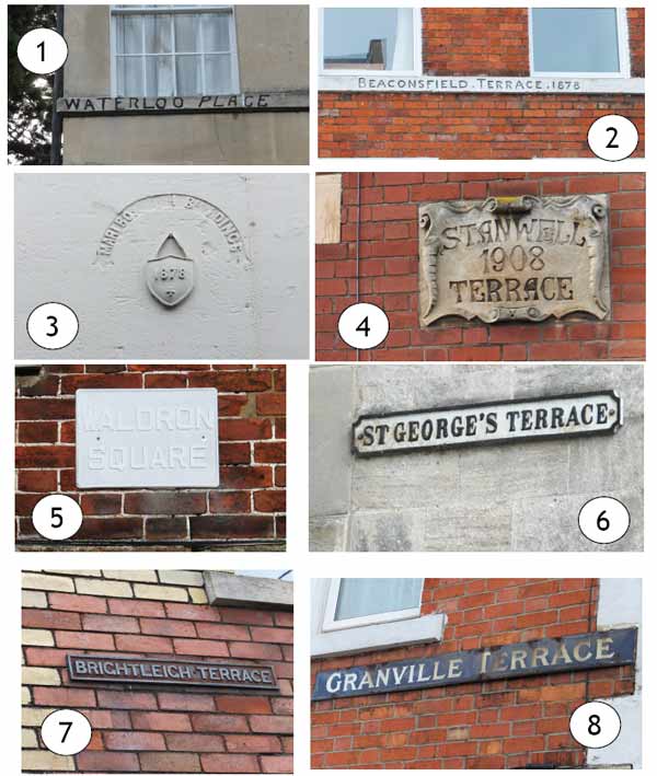 |
| Click on the plaque to reveal the answers - no cheating! |  |